GEOSEC: Revolutionising Ground Stabilisation with Integrated Geophysical Tools and 3D ERT
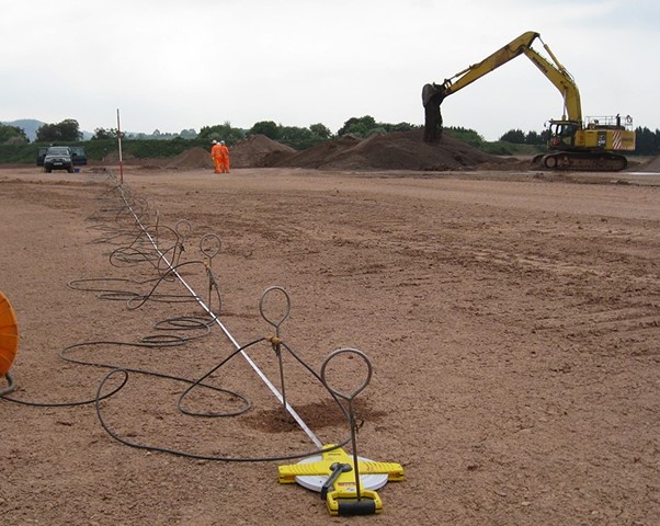
In the field of ground stabilisation and soil consolidation, innovation is key. GEOSEC, a leading company in this sector, has taken a significant step forward by incorporating geophysical tools into its interventions. Among these, the use of 3D Electrical Resistivity Tomography (ERT) has revolutionised how projects are executed, offering unparalleled precision and efficiency.
What is 3D ERT?
3D Electrical Resistivity Tomography (ERT) is a geophysical imaging technique that measures the electrical resistivity of subsurface materials. By injecting a controlled electrical current into the ground stability and analysing how it flows through the soil, ERT creates detailed 3D models of subsurface conditions. These models reveal variations in soil composition, moisture levels, and the presence of voids or weak zones, all of which are crucial for ground stabilisation projects.
How GEOSEC Integrates 3D ERT in Its Interventions
GEOSEC has seamlessly integrated 3D ERT into its ground stabilisation workflow. Here’s how this advanced tool enhances their interventions:
- Pre-Intervention Analysis Before beginning any project, GEOSEC uses 3D ERT to gain a detailed understanding of subsurface conditions. This helps identify critical areas requiring stabilisation and ensures precise targeting of resin injections.
- Real-Time Monitoring During the intervention, 3D ERT allows GEOSEC technicians to monitor the progress of resin injections in real time. By observing changes in resistivity, they can confirm the resin’s spread, ensuring comprehensive soil consolidation.
- Post-Intervention Validation Once the work is complete, GEOSEC conducts a final 3D ERT scan to validate the effectiveness of the intervention. The resulting data provides clear evidence of improved ground conditions and serves as a benchmark for long-term performance.
Benefits of Using 3D ERT in GEOSEC Projects
- Precision and Accuracy The detailed imaging provided by 3D ERT ensures that GEOSEC’s interventions are precisely targeted, minimising material waste and maximising effectiveness.
- Cost Efficiency By identifying the exact areas needing stabilisation, 3D ERT reduces unnecessary work, saving time and resources.
- Increased Client Confidence Clients receive transparent, data-driven insights into the work being done, along with post-intervention validation that confirms results.
- Environmentally Friendly Solutions The targeted approach enabled by 3D ERT minimises the environmental impact by reducing the amount of resin used and avoiding unnecessary disturbances to the ground.
Applications of GEOSEC’s 3D ERT Integration
GEOSEC’s use of 3D ERT has been successfully applied in a variety of projects, including:
- Stabilisation of industrial floors subject to heavy loads.
- Remediation of residential foundations impacted by subsidence.
- Consolidation of roads and infrastructure to prevent collapse.
- Preservation of heritage structures by reinforcing underlying soils.
Pioneering the Future of Ground Stabilisation
By integrating advanced geophysical tools like 3D ERT into its processes, GEOSEC continues to set the standard for innovation in ground stabilisation. This technology not only enhances the efficiency and reliability of their interventions but also underscores their commitment to precision and environmental stewardship.
For more information about GEOSEC’s groundbreaking solutions and how 3D ERT can benefit your project, visit [GEOSEC’s website] or contact their expert team today.